 |
 |
un-visited links�� active links�� visited links
|
|
un-visited links�� active links�� visited links
| Nov 30 |
Final escrow/closing on my house (1991, 1511sf, 3br, 2ba, 2car, cvrdpatio, rvprkng, cncrete walks side & back) I'm planning to shop hard for a digital camera this season, so pics of house should appear before Y2K. |
| Dec 01 | Movers delivered all my stuff to my house. Unpacking is a drag. |
| Dec 08 |
Still here and still liking it. Still not totally unpacked or organized. I'll eventually try to find some local WebCams to link to, and weather stuff. |
| Dec 11 | The Mid Pacific Construction Office X-mas party is in Orland tonite from 6pm to ??? |
| Dec 15 |
I drove to Portland via I-5. Mt. Shasta was pretty cool looking. It's about 2 to 2 1/5-hrs from my house. I visited with Jim, Natalia and Dave. Drove up the Columbia River to the town of Mt. Hood, visited a few pubs, and did some shopping at the Saturday Market in downtown Portland. |
| Dec 19 |
Drove back to Chico. I took a different route back, I-5 to Eugene, 58 to 97, 97 to I-5 at Mt. Shasta, then home. It was a really nice drive back, dry pavement all the way. I stopped by the highway and watched people ride the Ski lift up into and disappear into the Clouds at the Willamette Ski Park. I tried to detour and drive by Crater Lake but the road was closed for the winter. The trip was 500 miles, and took 9-hours each way. Great views of Mt. Shasta! |
| Dec 26 |
Drove up Hwy 32, to Chester and up into the southern Mt. Lassen area as far as I could. Almost got stuck in the snow so I came out again. Tried to drive up to the Stover Mt. Ski area, but it is closed now, and there was a locked gate. As I drove to it, I pasted a winter PLAY area with people sledding down a hill by the road.
Then I dove up to the entry station for Mt. Lassen National Park. I knew the road thru would be closed, but I wanted to see how far I'd get. They were letting people in to the first parking lot ( 1000' ), and from there they said that you could walk on packed snow ( 1.5 mi ) to the bubbling mud pits and some steam vents (it blew it's top in 1915). It was after 3:15 and it gets dark here about 5pm and they wanted $10.00 to get in, so I declined and drove back to Chico the long way via Hwy 36, to Red Bluff, then to Chico, about 1:50 min. |
 This one is on I-5, just north of the OR/CA border. The elev. is about 5,000 feet. |
 This cam is good, cause it's near Siskiyou and it holds the last picture before it gets dark each day. |
 This one is on Hwy 58, btwn Hwy 97 and Eugene, OR. It's elev. is about 5,200 feet. There's a ski resort right near here, right next to to highway. |
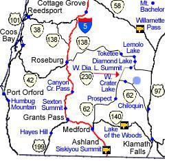 This is a roadmap that shows where these three ODOT CAMs are. This is a roadmap that shows where these three ODOT CAMs are. |
||
 This is Shasta Cam No. 01. |
Mt. Shasta is Southeast from the ODOT Cam at Siskiyou Summit. I don't know the CAMs elevation yet, but the top of the lift is 6,880 ft. Click Here to see a LARGE Mt. Shasta Trail Map. |
 This is Shasta Cam No. 02. |
 This is a Cam on Mt. Ashland. I think it's updated at least daily, but not on any set interval. |
The top of the lift at Mt. Ashland Ski Area is 7,500 ft. The base is 6,350. It has two double and two triple chairlifts. The longest run is 1-mile. |  This image is NOT updated at all. It just shows the trails. |
 |
